In September 2004 the Treasure Coast took two hurricanes in three weeks, and both came ashore on the same short stretch of coast. The Weather Prediction Center places the center of Frances at Sewall’s Point on September 5. It places the center of Jeanne’s eye crossing the coast at the southern end of Hutchinson Island, just east of Stuart, at midnight on the night of September 25. The second storm arrived 21 days after the first.
This page follows both storms through the National Hurricane Center’s advisories and discussions from the nights they made landfall, and the Weather Prediction Center’s storm summaries. All are listed under Sources at the end. Times are Eastern Daylight Time, as the advisories gave them.
Hurricane Frances: the night of September 4
Before Florida. Frances became a tropical depression over the far eastern tropical Atlantic on August 24 and a hurricane on August 26, the Weather Prediction Center records. It passed north of Puerto Rico at Category 4 strength, neared the Turks and Caicos Islands on September 2, and weakened to Category 3 as it crossed San Salvador Island in the Bahamas. From there it slowed down and kept weakening on its way to Florida.
Saturday, 11 p.m. The center sat about 35 miles northeast of West Palm Beach, moving west-northwest near 5 mph. The western part of the eyewall was already over parts of Palm Beach, Martin and St. Lucie counties. Maximum sustained winds were near 105 mph. Hurricane-force winds reached out up to 85 miles from the center and tropical-storm-force winds up to 200 miles. A Hurricane Warning covered the east coast from Florida City to Flagler Beach, Lake Okeechobee included.
Sunday, 3 a.m. The center was about 13 miles west of Stuart, moving west-northwest near 8 mph, with winds still near 105 mph. The advisory warned that the eastern half of the eye, with hurricane-force winds from the southeast and south, could take another one to two hours to reach parts of the Martin and St. Lucie county coastline, and it urged people in the eye to stay inside. A gust of 95 mph had been reported at the northern end of Lake Okeechobee.
Sunday, 5 a.m. Frances was just inland, about 20 miles west of Stuart, with winds near 100 mph. A reconnaissance aircraft had found a central pressure of 960 millibars right along the coast, and a Florida Coastal Monitoring Program tower at Port Salerno had since reported about 963. West Palm Beach had reported a sustained wind of 51 mph with a gust to 81 mph in the past hour.
After the Treasure Coast. Frances crossed the peninsula, reached the northeastern Gulf of Mexico on September 6 as a tropical storm, and made a second Florida landfall near St. Marks. It moved north across the eastern United States and dissipated over southeastern Canada.
Hurricane Jeanne: the night of September 25
Before Florida. Jeanne formed near the Leeward Islands on September 13 and crossed Puerto Rico and the eastern tip of the Dominican Republic, the Weather Prediction Center records. Its rains caused flooding and mudslides that killed thousands of people in Haiti. Then it stalled. With weak steering currents for five days, Jeanne drifted north over the southeastern Bahamas and made a slow loop about 500 nautical miles east of the northwestern Bahamas, becoming a 100 mph hurricane by the time the loop was done on September 23. A ridge of high pressure then pushed it on a track just north of due west, toward Florida.
Saturday morning, September 25. Jeanne’s winds reached 115 mph, Category 3, as the center moved over Abaco and then Grand Bahama Island.
Saturday, 11 p.m. The advisory’s headline said the eye was beginning to move onshore over Martin and St. Lucie counties. The center was about 15 miles east of Stuart, moving slightly north of west near 13 mph, and was expected to move inland near midnight. Winds were near 115 mph. Hurricane-force winds reached out up to 70 miles from the center and tropical-storm-force winds up to 205 miles. A Florida Coastal Monitoring Program tower near Vero Beach had reported a sustained wind of 68 mph with a gust to 94 mph. A Hurricane Warning covered the east coast from Florida City to St. Augustine, Lake Okeechobee included.
Midnight. The Weather Prediction Center’s summary puts the center of Jeanne’s eye, about 50 nautical miles across, crossing the coast at the southern end of Hutchinson Island just east of Stuart. It estimates the strongest winds at landfall at 120 mph, over a very small area north of the center, and says it is not clear whether those winds reached the coast or stayed over the water.
Sunday, 5 a.m. The eye, about 40 nautical miles wide in the Hurricane Center’s discussion, was over the south-central peninsula between Sebring and Vero Beach. Jeanne was down to 110 mph, Category 2, about 45 miles west-southwest of Vero Beach. A monitoring tower in Sebastian had reported a sustained wind of 67 mph with a gust to 81 mph. The advisory warned that hurricane-force winds could occur as far as 100 miles inland along the path.
After the Treasure Coast. Jeanne weakened to a tropical storm early that afternoon while centered about 30 nautical miles north of Tampa, crossed Georgia as a depression the next day, and moved off the mid-Atlantic coast on September 28.
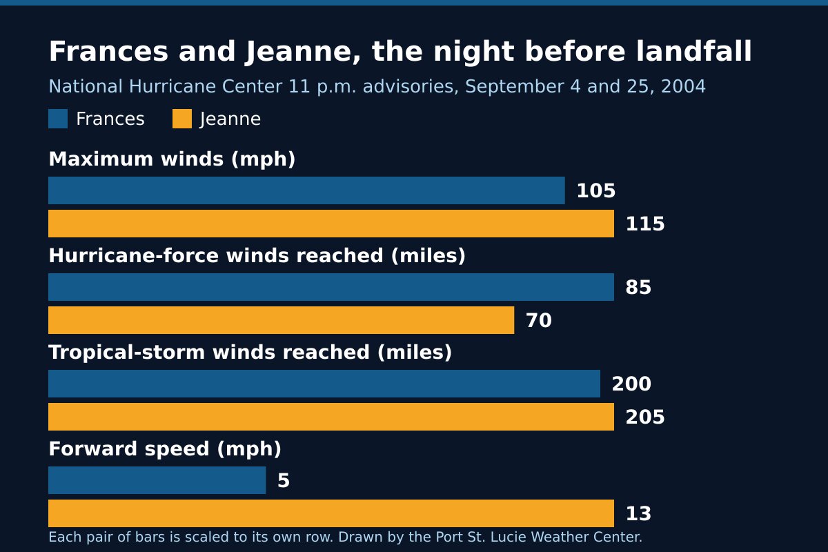
The two storms side by side
| Measure | Frances | Jeanne |
|---|---|---|
| Landfall | Sewall’s Point, early Sunday, September 5 | Southern end of Hutchinson Island, just east of Stuart, midnight Saturday, September 25 |
| Maximum winds, 11 p.m. advisory | 105 mph (Category 2) | 115 mph (Category 3) |
| Hurricane-force winds reached out | 85 miles | 70 miles |
| Tropical-storm-force winds reached out | 200 miles | 205 miles |
| Forward speed, 11 p.m. | about 5 mph | about 13 mph |
| Lowest pressure reported that night | 960 millibars | 953 millibars |
| Storm surge forecast near and north of landfall | 4 to 6 feet above normal tide | 4 to 7 feet above normal tide |
| Rain forecast for the peninsula | 8 to 12 inches, locally near 20 | 5 to 10 inches, isolated higher amounts |
The surge and rain lines are the forecasts the advisories issued that night. The sources on this page do not give measured water levels, rain totals or damage figures for St. Lucie County, so we have not printed any.
What the two storms show
A slow storm lasts longer. At 11 p.m. Frances was moving about 5 mph, and its eyewall was already over our three counties. At 3 a.m. the Hurricane Center was still telling people on the Martin and St. Lucie coast that the far side of the eye had not reached them. A storm moving at 5 mph keeps its winds over the same neighborhoods for hours.
The eye passes. People under the eye of Frances at 3 a.m. were told to stay inside, because the eastern half of the eye and its hurricane-force winds from the southeast and south had not reached them yet. When the wind drops in the middle of a hurricane, the rest of the storm is still coming.
One storm does not use up the season. Jeanne arrived three weeks after Frances, on nearly the same piece of coast. It had spent five days drifting and looping east of the Bahamas before it turned west. A season with one landfall behind it is still a season.
A weaker category is still a hurricane. Five hours after landfall, about 20 miles east of Sebring, Jeanne still had 110 mph winds, and the advisory warned of hurricane-force winds as far as 100 miles inland. Inland neighborhoods west of the turnpike are not out of reach.
Frequently asked questions about Frances and Jeanne
Sources
- Weather Prediction Center, Hurricane Frances, September 3-11, 2004 (formation, track, Sewall’s Point landfall, St. Marks landfall).
- Weather Prediction Center, Hurricane Jeanne, September 13-28, 2004 (formation, Caribbean, the loop, Hutchinson Island landfall and its estimated winds).
- National Hurricane Center, Hurricane Frances advisory archive and Hurricane Jeanne advisory archive.
- National Hurricane Center, Hurricane Frances Advisory 45, 11 p.m. Saturday, September 4, 2004; Intermediate Advisory 45B, 3 a.m. Sunday, September 5; Advisory 46 and Discussion 46, 5 a.m. Sunday, September 5.
- National Hurricane Center, Hurricane Jeanne Advisory 50, 11 p.m. Saturday, September 25, 2004; Advisory 51 and Discussion 51, 5 a.m. Sunday, September 26.
Before the next storm
Watch what is coming with our St. Lucie County alerts page and the live radar, or open the command center for everything at once. For the other storms that reached our coast, read Treasure Coast hurricane history and Hurricane Nicole, 2022. To get ready for the next one, start with the hurricane preparedness guide and hurricane water storage.