Hurricane Matthew is the storm the Treasure Coast prepared for and did not get. On the night of October 6, 2016, it was a Category 4 hurricane crossing Grand Bahama Island, aimed at the Florida coast. By morning its eye had run north-northwest past Vero Beach and Cape Canaveral, close offshore, and the worst of its winds had stayed over the water.
This page follows that night through the National Hurricane Center’s advisories and discussion and the Weather Prediction Center’s storm summary, all listed under Sources at the end. Times are Eastern Daylight Time, as the advisories gave them.
Before Florida
Matthew began as a tropical wave that left the west coast of Africa on September 23, the Weather Prediction Center records. It was named Tropical Storm Matthew on September 28, just west-northwest of Barbados, and became a hurricane in the Caribbean the next day. From late on the 29th to late on the 30th it strengthened rapidly into a major hurricane. It clipped western Haiti and eastern Cuba, then turned north-northwest, passing just west of Nassau on its way toward the east coast of Florida.
The night of October 6
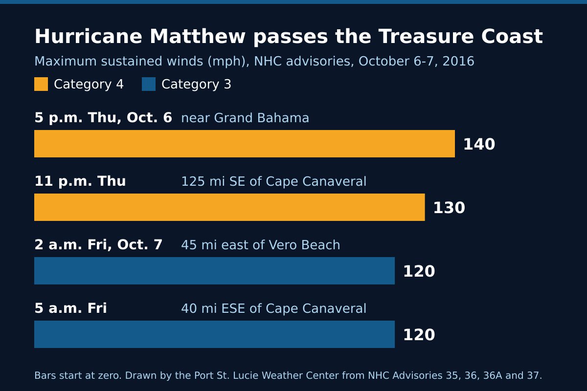
Thursday, 5 p.m. The eye was about 25 miles south-southeast of Freeport on Grand Bahama Island and about 100 miles east-southeast of West Palm Beach, moving northwest near 14 mph. Maximum sustained winds were near 140 mph, Category 4. Hurricane-force winds reached out up to 60 miles from the center and tropical-storm-force winds up to 185 miles. A Hurricane Warning covered the Florida coast from north of Golden Beach to the South Santee River in South Carolina, Lake Okeechobee included. The advisory’s headline warned of potentially disastrous impacts for Florida.
Thursday, 11 p.m. Matthew had moved away from the Bahamas and toward Florida, about 125 miles southeast of Cape Canaveral, with winds near 130 mph. The Hurricane Center expected it to stay at Category 3 or stronger as it moved near the coast. Its discussion that night said a reconnaissance aircraft and coastal radar showed two eyewalls, one inside the other, about 8 and 60 nautical miles across.
Friday, 2 a.m. The eye was about 45 miles east of Vero Beach and still moving northwest near 14 mph. Winds had dropped to near 120 mph, Category 3. In the past hour Vero Beach had reported a gust to 70 mph and Melbourne a gust to 60 mph.
Friday, 5 a.m. The headline said Matthew was moving parallel to the coast and just offshore, with its western eyewall approaching Cape Canaveral. The eye was about 40 miles east-southeast of the Cape. In the past hour Vero Beach had reported a sustained wind of 49 mph with a gust to 74 mph, and Melbourne a sustained wind of 47 mph with a gust to 69 mph. NOAA buoy 41009, off Cape Canaveral, reported a sustained wind of 65 mph with a gust to 78 mph.
The night at a glance
| Advisory time | Where the eye was | Maximum winds | Reported nearby |
|---|---|---|---|
| 5 p.m. Thursday, Oct. 6 | About 25 miles south-southeast of Freeport, Grand Bahama | 140 mph (Category 4) | Settlement Point, Bahamas: sustained 54 mph, gust 62 mph |
| 11 p.m. Thursday | About 125 miles southeast of Cape Canaveral | 130 mph (Category 4) | West end of Grand Bahama: pressure 943.1 millibars |
| 2 a.m. Friday, Oct. 7 | About 45 miles east of Vero Beach | 120 mph (Category 3) | Vero Beach: gust 70 mph |
| 5 a.m. Friday | About 40 miles east-southeast of Cape Canaveral | 120 mph (Category 3) | Vero Beach: sustained 49 mph, gust 74 mph |
That night’s advisories forecast a storm surge of 4 to 6 feet above ground from Boca Raton to Sebastian Inlet if the peak surge came at high tide, and 7 to 11 feet from Sebastian Inlet north into South Carolina. They forecast 6 to 12 inches of rain along the coast from central Florida to eastern North Carolina, raised to 8 to 12 inches by 5 a.m. These were forecasts. The sources on this page do not give measured water levels, rain totals or damage figures for St. Lucie County, so we have not printed any.
After the Treasure Coast
Matthew kept running north along the coast. By late on October 8 it had weakened below major hurricane strength off Georgia, the Weather Prediction Center records, and it made a brief landfall near McClellanville, South Carolina. It became an extratropical storm by the morning of the 9th, brushed Nova Scotia late on the 10th, and merged with a larger storm over Atlantic Canada on the 11th.
What Matthew shows
A storm running along the coast is hard to call. In its 11 p.m. discussion the Hurricane Center said that when a hurricane tracks roughly parallel to a coastline, it becomes very difficult to say what will happen at any one place. A small shift to the left of the forecast could have brought the core of a major hurricane ashore; a modest shift to the right could keep much of its hurricane-force wind offshore. Matthew went the second way here. Nothing in the forecast promised it would.
Offshore is still close. Hurricane-force winds reached out 60 miles from Matthew’s center and tropical-storm-force winds 185 miles. With the eye 45 miles off Vero Beach, the whole Treasure Coast sat inside the storm’s wind field, and Vero Beach measured gusts in the 70s.
Inland is not out of reach. The Hurricane Center warned that strong winds would reach well inland from the coast, and urged people in mobile homes under evacuation orders to heed them. It also warned that winds at the top of a 30-story building average about one category higher than at the ground.
Getting ready was the right call. On the night of October 6 the forecast had Matthew moving near or over the Florida coast as a major hurricane. It stayed offshore. The next storm on the same forecast may not.
Frequently asked questions about Hurricane Matthew
Sources
- Weather Prediction Center, Hurricane Matthew, October 4-10, 2016 (formation, Caribbean, Haiti and Cuba, the track off Florida, the South Carolina landfall, the end of the storm).
- National Hurricane Center, Hurricane Matthew advisory archive.
- National Hurricane Center, Hurricane Matthew Advisory 35, 5 p.m. Thursday, October 6, 2016; Advisory 36 and Discussion 36, 11 p.m. Thursday; Intermediate Advisory 36A, 2 a.m. Friday, October 7; Advisory 37, 5 a.m. Friday.
Before the next storm
Watch what is coming with our St. Lucie County alerts page and the live radar, or open the command center for everything at once. For the storms that did come ashore, read Hurricanes Frances and Jeanne, 2004, Hurricane Nicole, 2022 and Treasure Coast hurricane history. For another storm that stayed offshore, read Hurricane Dorian, 2019. To get ready for the next one, start with the hurricane preparedness guide.