Hurricane Dorian is the storm the Treasure Coast watched from a Friday to a Tuesday. On Friday, August 30, 2019, the Hurricane Center expected it to cross the northern Bahamas and come ashore in Florida. By the following Monday it was barely moving near Grand Bahama Island, and when it finally moved on, it went north, up the coast and out at sea.
This page follows those days through the National Hurricane Center’s advisories and discussions and the Weather Prediction Center’s storm summary, all listed under Sources at the end. Times are Eastern Daylight Time, as the advisories gave them.
Before the Bahamas
Dorian began as a tropical wave that moved off western Africa on August 19, the Weather Prediction Center records. It became Tropical Depression Five on the morning of the 24th, passed the Lesser Antilles on the 26th and 27th, and became a hurricane as it neared St. Thomas. Clear of the Caribbean, it rapidly intensified on the 30th into a major hurricane, then turned west toward the Bahamas and came ashore on Great Abaco Island near Marsh Harbour.
The forecast on Friday, August 30
That morning the Hurricane Center’s discussion said Dorian was expected to become an extremely dangerous major hurricane as it headed for the northwestern Bahamas and the Florida peninsula. Its forecast point for 8 a.m. on Tuesday, September 3, sat inland at 27.0 degrees north and 80.4 degrees west, about 30 miles south of Fort Pierce, with winds near 125 mph.
The same discussion named the catch. The steering currents were expected to weaken and Dorian to slow considerably near and over the peninsula, which raised the uncertainty in the four- and five-day track and meant a longer spell of wind, surge and rain wherever it went.
The stall, advisory by advisory
Monday, September 2, 11 a.m. The eye was about 30 miles northeast of Freeport on Grand Bahama Island and about 110 miles east of West Palm Beach, moving west near 1 mph. Maximum sustained winds were near 155 mph, an extremely dangerous Category 4 hurricane in the advisory’s words, and its headline said Grand Bahama was still taking catastrophic winds and storm surge. Hurricane-force winds reached out up to 45 miles from the center and tropical-storm-force winds up to 140 miles. The Hurricane Warning on Florida’s east coast was extended north to the Flagler and Volusia county line.
Tuesday, September 3, 11 a.m. The headline said Dorian was finally moving northwestward and growing in size. The eye was about 45 miles north of Freeport and about 105 miles east of Fort Pierce, moving northwest near 2 mph, with winds near 110 mph. Hurricane-force winds now reached up to 60 miles from the center and tropical-storm-force winds up to 175 miles. A Hurricane Warning covered the coast from Jupiter Inlet to Ponte Vedra Beach, and a Storm Surge Warning ran north from Jupiter Inlet.
Tuesday, 5 p.m. The headline said winds were increasing along portions of the Florida east coast. The center was about 105 miles east of Vero Beach, moving northwest near 6 mph, still near 110 mph. The Hurricane Warning from Sebastian Inlet to Jupiter Inlet was changed to a Tropical Storm Warning, and the advisory said tropical storm conditions would continue along the Treasure Coast that night. The discussion noted that the eye had become better defined on the National Weather Service Doppler radar in Melbourne.
Tuesday, 11 p.m. The headline said Dorian continued to lash the east coast of central Florida. The center was about 95 miles east of Cape Canaveral, winds still near 110 mph, and tropical storm conditions were expected to continue along the Treasure Coast for a few more hours.
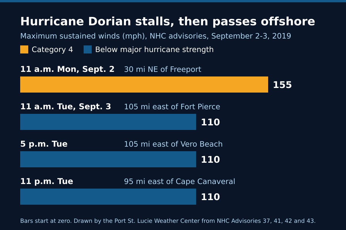
The two days at a glance
| Advisory time | Where the center was | Maximum winds | Moving |
|---|---|---|---|
| 11 a.m. Monday, Sept. 2 | About 30 miles northeast of Freeport, Grand Bahama | 155 mph (Category 4) | West near 1 mph |
| 11 a.m. Tuesday, Sept. 3 | About 105 miles east of Fort Pierce | 110 mph | Northwest near 2 mph |
| 5 p.m. Tuesday | About 105 miles east of Vero Beach | 110 mph | Northwest near 6 mph |
| 11 p.m. Tuesday | About 95 miles east of Cape Canaveral | 110 mph | North-northwest |
The Tuesday evening advisories forecast a storm surge of 2 to 4 feet above ground from Jupiter Inlet to the Volusia and Brevard county line if the peak surge came at high tide. The 11 p.m. advisory forecast 3 to 6 inches of rain along the Atlantic coast from Sebastian north to the Georgia and South Carolina line. These were forecasts. The sources on this page do not give measured winds, water levels, rain totals or damage figures for St. Lucie County, so we have not printed any.
After the Treasure Coast
Dorian ran north-northwest up the Gulf Stream, growing larger as it paralleled the Florida east coast, the Weather Prediction Center records. Off South Carolina it briefly regained major hurricane strength on September 5, and its center moved near Cape Hatteras on the 6th. It became fully extratropical on the 7th, reached Nova Scotia and northern Newfoundland, and dissipated on the 10th off southern Greenland.
What Dorian shows
A forecast four or five days out can move a long way. On August 30 the forecast point for Tuesday morning sat over land south of Fort Pierce. On Tuesday morning the center was about 105 miles east of Fort Pierce. The Hurricane Center had flagged the reason in advance: a storm that slows down near the coast is a harder track to call.
A slow storm is a long wait. On Monday Dorian moved west at about 1 mph, and on Tuesday morning northwest at about 2 mph. The Weather Prediction Center says it slowed as it reached the western edge of the high pressure that had steered it west, while a trough developed over the eastern United States. Over Grand Bahama that slow motion was catastrophic. Here it meant a Category 4 hurricane sitting about 110 miles off the Palm Beach coast while everyone waited for the turn.
A hundred miles out is still inside the wind field. By Tuesday tropical-storm-force winds reached up to 175 miles from Dorian’s center, and the Hurricane Center said tropical storm conditions would continue along the Treasure Coast that night, with the center about 105 miles away.
Getting ready was the right call. On the Friday before, the forecast had a major hurricane coming ashore on this coast. It turned. The next storm on the same forecast may not.
Frequently asked questions about Hurricane Dorian
Sources
- Weather Prediction Center, Hurricane Dorian, August 31 to September 9, 2019 (formation, the Bahamas, the stall and its cause, the track up the Gulf Stream, the end of the storm).
- National Hurricane Center, Hurricane Dorian advisory archive.
- National Hurricane Center, Hurricane Dorian Discussion 25, 11 a.m. Friday, August 30, 2019; Advisory 37, 11 a.m. Monday, September 2; Advisory 41, 11 a.m. Tuesday, September 3; Advisory 42 and Discussion 42, 5 p.m. Tuesday; Advisory 43, 11 p.m. Tuesday.
Before the next storm
Watch what is coming with our St. Lucie County alerts page and the live radar, or open the command center for everything at once. For another storm that passed offshore, read Hurricane Matthew, 2016, and for one that went up the other side of the state, Hurricane Irma, 2017; for one the following year that put us under a Hurricane Warning and passed offshore, Hurricane Isaias, 2020; for storms that came ashore, Hurricanes Frances and Jeanne, 2004 and Hurricane Nicole, 2022. The rest is in Treasure Coast hurricane history, and getting ready starts with the hurricane preparedness guide.