Hurricane Milton made landfall near Siesta Key, on the Gulf coast south of Tampa Bay, as a major hurricane late on Wednesday, October 9, 2024, the Weather Prediction Center records, and then crossed the peninsula roughly along Interstate 4. Fort Pierce is on the other side of the state, and St. Lucie County was still under a Hurricane Warning from 5 p.m. on Tuesday until 11 a.m. on Thursday. Hours before landfall, the National Hurricane Center’s first headline was about tornadoes, not wind or surge: tornadic supercells were starting to sweep across the southern Florida peninsula.
This page follows those days through the National Hurricane Center’s advisories, with the Weather Prediction Center’s storm summary for the start and the end of the storm, all listed under Sources at the end. Times are Eastern Daylight Time. The distances from Fort Pierce are our own arithmetic from the positions in each advisory.
Before Florida
Milton grew out of a low in the Bay of Campeche and became a tropical depression and then a tropical storm on October 4, the Weather Prediction Center records, moving east, which it calls an unusual motion. It became a hurricane on the afternoon of the 6th and a major hurricane early on the 7th as it approached the north coast of the Yucatan Peninsula.
Monday, October 7: the watch
11 p.m. Milton was a Category 5 hurricane with maximum sustained winds near 165 mph, about 35 miles north-northwest of Progreso, Mexico, and about 715 miles from Fort Pierce. The advisory’s headline said Milton posed an extremely serious threat to Florida. A Hurricane Warning covered the west coast from Bonita Beach to the Suwannee River, Tampa Bay included. On our coast, a Hurricane Watch ran from the St. Lucie and Indian River county line north, and a Tropical Storm Watch covered the east coast south of that line, which took in St. Lucie County itself.
Tuesday, October 8: the warning
5 p.m. Milton was back to Category 5, with winds near 165 mph, about 320 miles west-southwest of the Dry Tortugas and about 555 miles from Fort Pierce. This advisory extended the Hurricane Warning on Florida’s east coast south to the St. Lucie and Martin county line, which put the whole St. Lucie County coast inside it. Martin County went under a Hurricane Watch. On the Gulf side, the advisory forecast a storm surge of 10 to 15 feet for Tampa Bay if the peak came at high tide.
Wednesday, October 9: the tornadoes come first
11 a.m. The center was still over the Gulf, about 160 miles west-southwest of Fort Myers and about 270 miles from Fort Pierce, with winds near 145 mph, Category 4. The advisory’s first headline was that tornadic supercells from Milton were beginning to sweep across the southern Florida peninsula, and it said several tornadoes were likely that day and night across parts of central and southern Florida. It expected tropical storm conditions to start on the west coast within a few hours and reach the east coast that night, and rain of 6 to 12 inches, up to 18 in places, across central to northern parts of the peninsula.
Milton made landfall near Siesta Key late that evening, the Weather Prediction Center records.
11 p.m. The center was inland, about 75 miles southwest of Orlando and about 105 miles from Fort Pierce, moving east-northeast near 16 mph with winds near 105 mph. The advisory expected Milton to stay a hurricane across the state overnight and come off the east coast on Thursday, and it said a tornado or two was possible through early Thursday morning over parts of central and eastern Florida.
Thursday, October 10: off the east coast
5 a.m. Milton was moving off the coast about 10 miles northeast of Cape Canaveral, about 75 miles from Fort Pierce, with winds near 85 mph. The headline said it was still producing damaging hurricane-force winds and heavy rain in east-central Florida. Tropical-storm-force winds reached out up to 205 miles from the center, and our Hurricane Warning was still up.
11 a.m. The center was about 135 miles east-northeast of Cape Canaveral and about 160 miles from Fort Pierce, with winds near 80 mph. The Hurricane Warning from Sebastian Inlet north was changed to a Tropical Storm Warning, and the warnings south of Sebastian Inlet were discontinued. Our Hurricane Warning had been up for 42 hours.
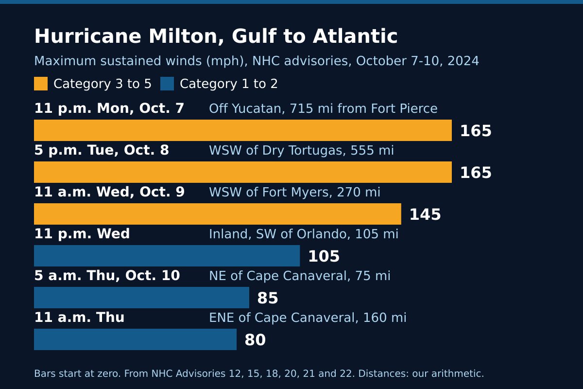
Hurricane Milton 2024 at a glance
| Advisory time | Where the center was | Distance from Fort Pierce | Maximum winds |
|---|---|---|---|
| 11 p.m. Monday, Oct. 7 | About 35 miles north-northwest of Progreso, Mexico | About 715 miles | 165 mph (Category 5) |
| 5 p.m. Tuesday, Oct. 8 | About 320 miles west-southwest of the Dry Tortugas | About 555 miles | 165 mph (Category 5) |
| 11 a.m. Wednesday, Oct. 9 | About 160 miles west-southwest of Fort Myers | About 270 miles | 145 mph (Category 4) |
| 11 p.m. Wednesday | Inland, about 75 miles southwest of Orlando | About 105 miles | 105 mph (Category 2) |
| 5 a.m. Thursday, Oct. 10 | About 10 miles northeast of Cape Canaveral | About 75 miles | 85 mph (Category 1) |
| 11 a.m. Thursday | About 135 miles east-northeast of Cape Canaveral | About 160 miles | 80 mph (Category 1) |
The advisories forecast tornadoes, rain and surge by region. None of the sources on this page gives tornado reports, measured winds, rain totals or damage figures for St. Lucie County, so we have not printed any.
After Florida
Milton came off the east coast as a hurricane-force low, the Weather Prediction Center records, losing its tropical characteristics as it went. By 5 p.m. on Thursday the Hurricane Center called it post-tropical, with winds near 70 mph, and no coastal watches or warnings were left in effect. It passed south of Bermuda on the 11th.
What Milton shows
A Gulf landfall can still bring a Hurricane Warning to our coast. Milton came ashore across the state from us, and St. Lucie County was under a Hurricane Warning anyway. At 5 a.m. Thursday, as it left, its tropical-storm-force winds reached out 205 miles from the center.
Tornadoes can come before the storm does. When the 11 a.m. Wednesday advisory led with tornadic supercells, Milton’s center was still over the Gulf, about 270 miles from Fort Pierce. A Tornado Warning in the rain bands of a distant hurricane is as real as any other; what it asks of you is in weather alert types explained.
Warnings come down one stretch of coast at a time. Ours came down at 11 a.m. Thursday, while the coast north of Sebastian Inlet stayed under a Tropical Storm Warning. Go by the warning for your own stretch of coast, not the storm’s headline, before going back out.
Frequently asked questions about Hurricane Milton
Sources
- Weather Prediction Center, Hurricane Milton, October 8 to 10, 2024 (formation and track, the Siesta Key landfall, the crossing along Interstate 4, the end of the storm, rainfall maps).
- National Hurricane Center, Hurricane Milton Advisory 12, 11 p.m. Monday, October 7, 2024; Advisory 15, 5 p.m. Tuesday, October 8.
- National Hurricane Center, Advisory 18, 11 a.m. Wednesday, October 9; Advisory 20, 11 p.m. Wednesday.
- National Hurricane Center, Advisory 21, 5 a.m. Thursday, October 10; Advisory 22, 11 a.m. Thursday; Advisory 23, 5 p.m. Thursday.
Before the next storm
Watch what is coming with our St. Lucie County alerts page and the live radar, or open the command center for everything at once. For another storm that came ashore on the Gulf coast and still put us under a warning, read Hurricane Ian, 2022; for one that crossed the state in a morning, Hurricane Wilma, 2005. The rest is in Treasure Coast hurricane history, and getting ready starts with the hurricane preparedness guide.