Hurricane Wilma is the storm that crossed the whole state in a morning. It struck Cape Romano, south of Naples, on Monday, October 24, 2005, and crossed Florida in about five hours with its winds barely lower, the Weather Prediction Center records. At 11 a.m. the National Hurricane Center placed its center about 15 miles north-northeast of West Palm Beach, about 45 miles south-southeast of Fort Pierce, and said the large eye was over Palm Beach and Martin counties. St. Lucie County had been under a Hurricane Warning since 5 a.m. the day before.
This page follows those days through the National Hurricane Center’s advisories, with the Weather Prediction Center’s storm summary for the start and the end of the storm, all listed under Sources at the end. Times are Eastern Daylight Time. The distances from Fort Pierce are our own arithmetic from the positions in each advisory.
Before Florida
Wilma became a tropical depression on October 15 about 215 miles southeast of Grand Cayman, the Weather Prediction Center records, and a hurricane on the 18th. On the 19th it became a Category 5 hurricane with maximum sustained winds of 175 mph, and its central pressure fell to an estimated 882 millibars, the lowest on record for a hurricane in the Atlantic basin. It struck Cozumel on the 21st and the northeast Yucatan peninsula early on the 22nd, both at Category 4, and weakened slowly as it drifted there.
Saturday, October 22: the watch
11 p.m. A Hurricane Warning went up for the Florida Keys, the west coast from Longboat Key south, and the east coast from Jupiter Inlet south, Lake Okeechobee included. North of Jupiter Inlet to Titusville, which takes in the whole Treasure Coast, a Hurricane Watch stayed in effect, and the advisory said Hurricane Warnings would likely be needed there on Sunday morning.
Sunday, October 23: the warning
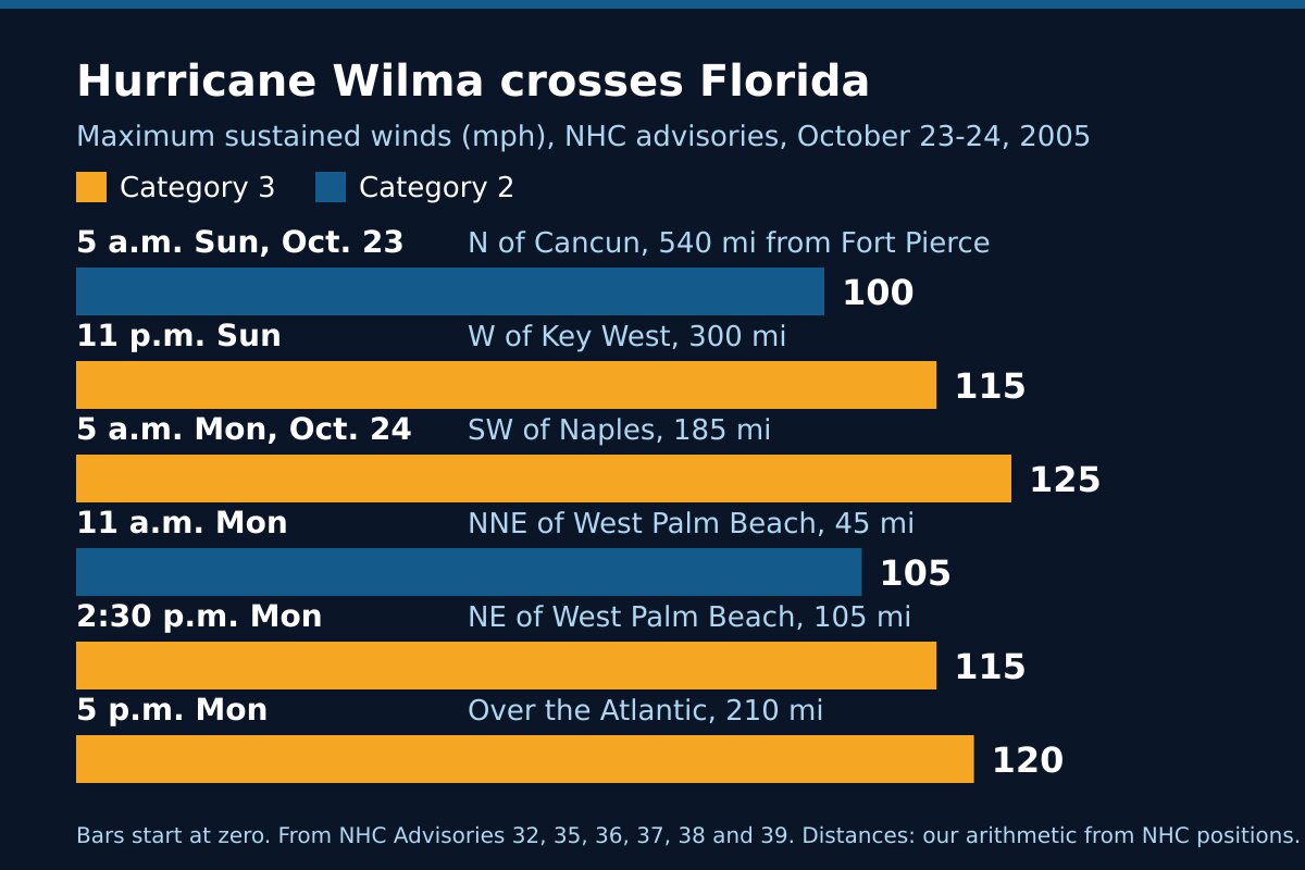
5 a.m. The watch north of Jupiter Inlet to Titusville was replaced by a Hurricane Warning. Wilma itself was still about 40 miles north of Cancun, about 540 miles from Fort Pierce, moving northeast near 3 mph with maximum sustained winds near 100 mph, a Category 2 hurricane.
11 a.m. The center was about 285 miles west-southwest of Key West, moving northeast near 8 mph, with winds still near 100 mph. Hurricane-force winds reached out up to 70 miles from the center and tropical-storm-force winds up to 200 miles.
11 p.m. Wilma had become a major hurricane, Category 3, with winds near 115 mph. Its center was about 120 miles west of Key West, about 300 miles from Fort Pierce, and it was moving northeast near 18 mph. The advisory warned that Wilma was a large hurricane and that tropical-storm-force winds would reach the Florida peninsula well before the eye made landfall.
Monday, October 24: across the state
5 a.m. The center was about 55 miles southwest of Naples, about 185 miles from Fort Pierce, with winds near 125 mph, a strong Category 3. Hurricane-force winds reached out up to 90 miles from the center and tropical-storm-force winds up to 230 miles. The advisory expected 4 to 6 inches of rain across central and southern Florida, with up to 10 inches in places, and said tornadoes were possible on the peninsula that day.
Wilma made landfall at Cape Romano that morning. Across Florida its central pressure rose only 4 millibars, the Weather Prediction Center records, and the worst wind damage it describes was in Deerfield Beach and Boca Raton, which stayed in the eyewall the longest.
11 a.m. The center was about 15 miles north-northeast of West Palm Beach, about 45 miles from Fort Pierce, moving northeast near 25 mph with winds near 105 mph. The advisory’s headline put the large eye over Palm Beach and Martin counties and told people to remain indoors. The strongest winds in the eyewall reached well away from the center, it said, and anyone who went out in the calm of the eye would find the winds rising again quickly. Hurricane-force winds reached out up to 100 miles from the center. As Wilma left Florida, storm surge flooding of 2 to 4 feet was still possible along the Palm Beach, Martin and St. Lucie shorelines north of the track.
2:30 p.m. Back over the Atlantic, about 125 miles northeast of West Palm Beach and about 105 miles from Fort Pierce, Wilma had regained Category 3 strength, with winds near 115 mph. The Hurricane Warning on the east coast from Titusville south to Florida City was still up.
5 p.m. All hurricane and tropical storm warnings for the Florida peninsula were discontinued. Wilma was about 210 miles from Fort Pierce, racing northeast near 37 mph with winds near 120 mph. Our Hurricane Warning had been up for 36 hours.
The two days at a glance
| Advisory time | Where the center was | Distance from Fort Pierce | Maximum winds |
|---|---|---|---|
| 5 a.m. Sunday, Oct. 23 | About 40 miles north of Cancun | About 540 miles | 100 mph (Category 2) |
| 11 p.m. Sunday | About 120 miles west of Key West | About 300 miles | 115 mph (Category 3) |
| 5 a.m. Monday, Oct. 24 | About 55 miles southwest of Naples | About 185 miles | 125 mph (Category 3) |
| 11 a.m. Monday | About 15 miles north-northeast of West Palm Beach | About 45 miles | 105 mph (Category 2) |
| 2:30 p.m. Monday | About 125 miles northeast of West Palm Beach | About 105 miles | 115 mph (Category 3) |
| 5 p.m. Monday | Over the Atlantic, heading northeast | About 210 miles | 120 mph (Category 3) |
The advisories forecast rain and surge by region, and the 11 a.m. advisory named the St. Lucie shoreline in its surge forecast. None of the sources on this page gives measured winds, rain totals, water levels or damage figures for St. Lucie County, so we have not printed any.
After Florida
Wilma weakened slowly as it moved rapidly northeast across the western Atlantic, the Weather Prediction Center records, and lost its tropical characteristics about 205 miles south-southeast of Halifax, Nova Scotia, on October 25.
What Wilma shows
Stay inside through the eye. The 11 a.m. advisory said it in plain words: the calm of the eye is brief, and the winds on its far side come quickly. When the eye of a large storm passes over, the second half is still to come.
A storm from the Gulf can cross in a morning. Wilma took about five hours to cross the state and lost little strength doing it. It was a Category 3 hurricane before landfall, and again three and a half hours after the 11 a.m. advisory placed it near West Palm Beach.
Use the warning from its first hour. Our Hurricane Warning went up at 5 a.m. on Sunday, when Wilma was still near Cancun, about 540 miles away and moving at 3 mph. A day and a half later the eye was passing 45 miles to the south.
Frequently asked questions about Hurricane Wilma
Sources
- Weather Prediction Center, Hurricane Wilma, October 22 to 25, 2005 (formation, record pressure, the Cozumel, Yucatan and Cape Romano landfalls, the five-hour crossing, the end of the storm, rainfall maps).
- National Hurricane Center, Hurricane Wilma Advisory 31, 11 p.m. Saturday, October 22, 2005.
- National Hurricane Center, Advisory 32, 5 a.m. Sunday, October 23; Advisory 33, 11 a.m. Sunday; Advisory 35, 11 p.m. Sunday.
- National Hurricane Center, Advisory 36, 5 a.m. Monday, October 24; Advisory 37, 11 a.m. Monday; Special Advisory 38, 2:30 p.m. Monday; Advisory 39, 5 p.m. Monday.
Before the next storm
Watch what is coming with our St. Lucie County alerts page and the live radar, or open the command center for everything at once. What each warning means is in weather alert types explained. For another storm that crossed the state from the Gulf side, read Hurricane Ian, 2022; for a tropical storm that crossed from the Gulf side three years later, Tropical Storm Fay, 2008; for the two storms of the year before, Hurricanes Frances and Jeanne, 2004. The rest is in Treasure Coast hurricane history, and getting ready starts with the hurricane preparedness guide.