Hurricane Ian is the storm that came at us from the Gulf side. It struck southwest Florida as a Category 4 hurricane on Wednesday, September 28, 2022, and crossed the state that night and the next morning. At 5 a.m. on Thursday its center was about 50 miles north-northwest of Fort Pierce. St. Lucie County was under a Tropical Storm Warning from Tuesday morning to Thursday evening, and for part of that time the Hurricane Warning on the east coast began at Sebastian Inlet, on the Brevard and Indian River county line.
This page follows those days through the National Hurricane Center’s advisories, with the Weather Prediction Center’s storm summary for the start and the end of the storm, all listed under Sources at the end. Times are Eastern Daylight Time, as the advisories gave them. The distances from Fort Pierce are our own arithmetic from the positions in each advisory.
Before Florida
Ian began as a tropical wave that moved off the African coast on September 14, the Weather Prediction Center records. It became Tropical Depression Nine on September 23 and Tropical Storm Ian that evening in the central Caribbean, then turned sharply north-northwest and became a hurricane. It crossed western Cuba as a major hurricane. At 5 a.m. on Tuesday, September 27, the Hurricane Center placed it about 5 miles south of the city of Pinar del Rio, with maximum sustained winds near 125 mph.
Tuesday, September 27: the warning
5 a.m. With that same advisory a Tropical Storm Warning was issued for Florida’s east coast from Jupiter Inlet north to the Volusia and Brevard county line, Lake Okeechobee included. That put the Treasure Coast under its first warning for Ian while the center was still over Cuba, about 415 miles from Fort Pierce.
5 p.m. The center was about 230 miles south of Sarasota, with winds near 120 mph. The advisory said tropical storm conditions were expected in the warning area on the east coast of Florida beginning early Wednesday.
Wednesday, September 28: landfall
7 a.m. Ian was rapidly intensifying, the advisory said, with winds near 155 mph and its eye placed by Hurricane Hunter aircraft about 65 miles west-southwest of Naples. It was forecast to make landfall on the west coast of Florida as a catastrophic Category 4 hurricane, and its tropical-storm-force winds reached out up to 175 miles from the center.
Ian made landfall at Cayo Costa, south of Punta Gorda, the Weather Prediction Center records.
5 p.m. The eye was about 5 miles east of Punta Gorda, about 110 miles from Fort Pierce, with winds near 140 mph. A Hurricane Warning now covered the east coast from Sebastian Inlet north to the Flagler and Volusia county line, and the coast from Sebastian Inlet south stayed under a Tropical Storm Warning.
The advisory said tropical storm conditions were occurring in parts of the warning area on the east coast, that Ian could be near hurricane strength when it moved over the east coast on Thursday, and that a few tornadoes were possible that evening and night across east central Florida. It also warned that swells would build along the east coast and cause life-threatening surf and rip currents.
11 p.m. The center was about 70 miles south of Orlando, about 65 miles west of Fort Pierce, moving north-northeast near 8 mph. Its winds had dropped to near 90 mph over land. Tropical-storm-force winds still reached out up to 175 miles from the center. The Tropical Storm Warning south of Boca Raton was taken down; from Boca Raton to Sebastian Inlet it stayed up.
Thursday, September 29: back over the Atlantic
5 a.m. Ian was now a tropical storm, with winds near 65 mph. Its center was about 35 miles southwest of Cape Canaveral, about 50 miles north-northwest of Fort Pierce. The Hurricane Warnings on both coasts of the peninsula were changed to Tropical Storm Warnings, and the advisory said tropical-storm-force winds now reached out up to 415 miles from the center. A station at New Smyrna Beach had just reported a sustained wind of 61 mph with a gust of 77 mph.
11 a.m. The center was about 25 miles north-northeast of Cape Canaveral, with winds near 70 mph, and the advisory expected Ian to become a hurricane again that evening. The Tropical Storm Warning on the Atlantic coast now ran from Jupiter Inlet north to Duck, North Carolina.
5 p.m. Ian was a hurricane again, with winds near 75 mph, about 240 miles south of Charleston. The Tropical Storm Warning on the Florida coast now began at Vero Beach, north of St. Lucie County, so the county’s warning had come down. It had been up about 60 hours.
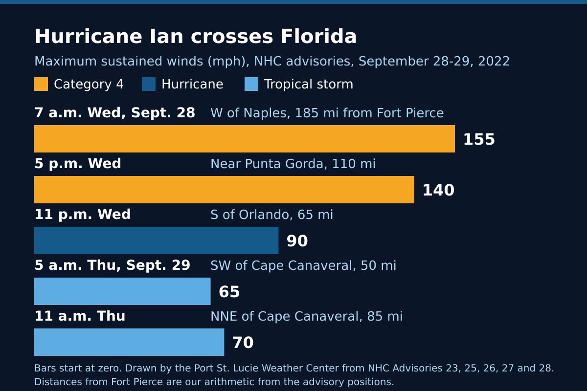
The two days at a glance
| Advisory time | Where the center was | Distance from Fort Pierce | Maximum winds |
|---|---|---|---|
| 7 a.m. Wednesday, Sept. 28 | About 65 miles west-southwest of Naples | About 185 miles | 155 mph (Category 4) |
| 5 p.m. Wednesday | About 5 miles east of Punta Gorda | About 110 miles | 140 mph (Category 4) |
| 11 p.m. Wednesday | About 70 miles south of Orlando | About 65 miles | 90 mph |
| 5 a.m. Thursday, Sept. 29 | About 35 miles southwest of Cape Canaveral | About 50 miles | 65 mph (tropical storm) |
| 11 a.m. Thursday | About 25 miles north-northeast of Cape Canaveral | About 85 miles | 70 mph (tropical storm) |
The advisories gave rain forecasts by region, such as 12 to 20 inches for central and northeast Florida on Wednesday evening, but none of the ones we cite names the Treasure Coast, and the sources on this page do not give measured winds, rain totals, water levels or damage figures for St. Lucie County. So we have not printed any.
After Florida
Ian began turning into a non-tropical storm as it crossed central Florida, the Weather Prediction Center records. It strengthened briefly back into a hurricane off northeast Florida, moved inland near Georgetown, South Carolina, and its circulation weakened out of existence over western Virginia.
What Ian shows
A storm from the Gulf side still reaches this coast. Ian came ashore about 110 miles from Fort Pierce, and by early Thursday its center had crossed the state to within about 50 miles of us. Our warning went up on Tuesday morning, while Ian was still over Cuba.
Warning lines are drawn at landmarks. For Ian the Hurricane Warning on the east coast began at Sebastian Inlet, and the Tropical Storm Warning south of it covered St. Lucie County. Know which inlet your home is near, so a warning read aloud on the radio means something.
The wind field grows as a storm weakens. Ian’s strongest winds fell from 140 mph to 65 mph between Wednesday evening and Thursday morning, while the reach of its tropical-storm-force winds went from 175 miles to 415 miles.
Frequently asked questions about Hurricane Ian
Sources
- Weather Prediction Center, Hurricane Ian, September 25 to October 1, 2022 (formation, Cuba, the Cayo Costa landfall, the crossing of central Florida, the end of the storm, rainfall maps).
- National Hurricane Center, Hurricane Ian Advisory 17, 5 a.m. Tuesday, September 27, 2022; Advisory 19, 5 p.m. Tuesday.
- National Hurricane Center, Special Advisory 23, 7 a.m. Wednesday, September 28; Advisory 25, 5 p.m. Wednesday; Advisory 26, 11 p.m. Wednesday.
- National Hurricane Center, Advisory 27, 5 a.m. Thursday, September 29; Advisory 28, 11 a.m. Thursday; Advisory 29, 5 p.m. Thursday.
Before the next storm
Watch what is coming with our St. Lucie County alerts page and the live radar, or open the command center for everything at once. What each warning means is in weather alert types explained, and the surf that follows a storm is in rip currents on the Treasure Coast. For another storm whose center passed west of us, read Hurricane Irma, 2017; for one that came ashore near Vero Beach six weeks after Ian, Hurricane Nicole, 2022. Wilma crossed the state from the same side in 2005, in about five hours: Hurricane Wilma, 2005. Two years later Milton came ashore on the same coast, and that time St. Lucie County was under a Hurricane Warning: Hurricane Milton, 2024. The rest is in Treasure Coast hurricane history, and getting ready starts with the hurricane preparedness guide.