Buoy 41114 is the wave buoy off Fort Pierce, and the place to look before a run offshore. Its page on NOAA’s National Data Buoy Center lists wave height, two kinds of wave period, wave direction and the temperature of the sea, refreshed through the day.
This page explains where the Fort Pierce buoy is, what each of those numbers means, and what one real day of readings looked like. The definitions come from the National Data Buoy Center; the sources are listed at the end.
Where the Fort Pierce buoy is
Station 41114 is named “Fort Pierce, FL” on the National Data Buoy Center’s station list. It is a Waverider buoy, and its information is submitted by Scripps Institution of Oceanography. The buoy sits at 27.564 N, 80.215 W, in 16 meters of water, which is about 52 feet. Its sea temperature sensor rides 0.46 meters below the waterline, about 18 inches down.
Everything the buoy reports describes the sea at that one spot. Conditions in the inlet, along the beach or on the Indian River Lagoon can be different, so read it as the offshore picture.
What each number means
“Significant wave height (meters) is calculated as the average of the highest one-third of all of the wave heights during the 20-minute sampling period.”
- Wave height (WVHT). The significant wave height defined above. Because it averages the biggest third of the waves, some waves in that sample will be bigger than the figure and many will be smaller. The buoy center records it in meters; its page shows feet when you choose Imperial units.
- Dominant wave period (DPD). The period, in seconds, with the most wave energy. Wave period is the time between one wave and the next.
- Average wave period (APD). The average period, in seconds, of all the waves in the 20-minute sample.
- Mean wave direction (MWD). The direction the waves at the dominant period are coming from, in degrees from true north: north is 0 and east is 90. The page also gives it as a compass point, such as ENE.
- Water temperature (WTMP). The sea surface temperature, measured at the sensor depth below the buoy’s waterline.
Reading a real day: October 31, 2026
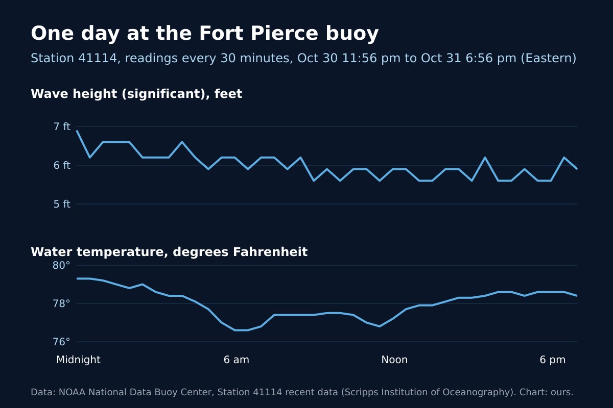
At 6:56 pm Eastern time on October 31, 2026, the Fort Pierce buoy read a wave height of 5.9 feet, a dominant period of 7 seconds, an average period of 5.2 seconds, waves from the east-northeast (58 degrees), and water at 78.4 degrees Fahrenheit. It posted a new reading every 30 minutes that day.
Across the 19 hours shown in the chart, wave height stayed between 5.6 and 6.9 feet and the waves came from the northeast or east-northeast in every reading. The water moved between 76.6 and 79.3 degrees. The dominant period ran between 5 and 10 seconds. Put together, the numbers describe a steady sea of waves around six feet, all day, from one direction.
What the buoy does not tell you
On October 31, 2026 the buoy’s table carried no wind speed, gusts, air pressure or air temperature: those columns were empty, and only the wave and sea temperature columns held numbers. For wind, and for the forecast of what the sea will do next, use the National Weather Service marine forecast. The buoy tells you what the sea is doing now at one place offshore.
The station page also carries a note from the buoy center for anglers headed to the Oculina Bank, pointing them to the fishing regulations there. Read those before you go.
Frequently asked questions about the Fort Pierce buoy
Sources
- National Data Buoy Center, Station 41114, Fort Pierce, FL (station details and recent data, read October 31, 2026).
- National Data Buoy Center, Measurement Descriptions and Units.
Before you head out
Check for storms on the live radar, see whether a marine or beach alert is up on our St. Lucie County alerts page, or open the command center for everything at once. Headed for the beach instead? Read our guide to rip currents, and for summer afternoons, lightning safety.