Isaias crossed the Bahamas as a hurricane and came up the Florida east coast on Sunday, August 2, 2020, its center staying offshore over the Gulf Stream, the Weather Prediction Center records. St. Lucie County went under a Hurricane Warning at 5 p.m. on Friday. By the time the center came abreast of Fort Pierce, Isaias had weakened to a tropical storm, the warning had been lowered to a Tropical Storm Warning, and the gusts reaching the coast were tropical-storm-force. Isaias regained hurricane strength the next day, off South Carolina, and made its last landfall in North Carolina.
This page follows those days through the National Hurricane Center’s advisories, with the Weather Prediction Center’s storm summary for the start and the end of the storm, all listed under Sources at the end. Times are Eastern Daylight Time. The distances from Fort Pierce are our own arithmetic from the positions in each advisory, except where we quote the Hurricane Center’s own.
Before Florida
Isaias began as a tropical wave that left the coast of Africa on July 24, the Weather Prediction Center records. It became a tropical storm late on July 29 south of Puerto Rico, made landfall in the southeastern Dominican Republic on the 30th, and became a hurricane that evening just off the north coast of Hispaniola. Early on the 31st its center crossed Great Inagua Island in the southeastern Bahamas.
Friday, July 31: the watch, then the warning
5 a.m. Isaias was a hurricane with maximum sustained winds near 80 mph, about 15 miles south-southwest of Great Inagua Island and about 630 miles from Fort Pierce. A Tropical Storm Watch was already in effect on Florida’s east coast from Ocean Reef to Sebastian Inlet, which took in St. Lucie County, and for Lake Okeechobee. The advisory said tropical storm conditions were possible in the Florida watch area beginning Saturday, and that more watches or warnings might be needed for the peninsula later that day.
5 p.m. They came. This advisory put a Hurricane Warning on the east coast from Boca Raton to the Volusia and Brevard county line, which covered the whole St. Lucie County coast, and a Storm Surge Watch from Jupiter Inlet to Ponte Vedra Beach, which covered it too. Isaias was about 195 miles south-southeast of Nassau and about 445 miles from Fort Pierce, with winds near 75 mph.
Saturday, August 1: a hurricane, then a tropical storm
5 a.m. The center was approaching Andros Island, about 80 miles south-southeast of Nassau and about 315 miles from Fort Pierce, with winds near 85 mph. The headline said Isaias was expected to approach the southeast coast of Florida later that day and Sunday.
Isaias made landfall on Andros Island at about 9 a.m., the Weather Prediction Center records, and weakened to a tropical storm by early afternoon as it moved back over water.
5 p.m. The Hurricane Center’s headline said Isaias had weakened to a tropical storm and was expected to regain hurricane strength overnight as it approached the coast. Its winds were near 70 mph, about 115 miles southeast of Fort Lauderdale and about 190 miles from Fort Pierce. Our Hurricane Warning stayed up.
11 p.m. Still a tropical storm, with winds near 70 mph, about 105 miles southeast of West Palm Beach and about 155 miles from Fort Pierce. The advisory expected hurricane conditions to reach the coast in the warning area Sunday morning and spread north through Sunday night, with tropical-storm-force winds arriving first, later that night. For the coast from Jupiter Inlet to Ponte Vedra Beach it forecast a storm surge that could put 2 to 4 feet of water above normally dry ground somewhere in that stretch, if the peak came at high tide.
Sunday, August 2: past Fort Pierce
5 a.m. Isaias had not regained hurricane strength. Its winds were near 65 mph, with the center about 45 miles southeast of West Palm Beach and about 95 miles from Fort Pierce, and this advisory replaced the Hurricane Warning on Florida’s east coast with a Tropical Storm Warning. Our Hurricane Warning had been up for 36 hours.
11 a.m. The Hurricane Center placed the center, by NOAA Doppler radar, about 55 miles southeast of Fort Pierce, moving north-northwest near 8 mph with winds near 65 mph. It reported tropical-storm-force wind gusts observed along the coast from Juno Beach north to Port St. Lucie. The Storm Surge Watch for the Florida east coast was discontinued, and the advisory expected 2 to 4 inches of rain in eastern Florida, with isolated totals of 6 inches.
2 p.m. The headline had Isaias moving slowly north-northwest just offshore the east-central Florida coast. The center was about 45 miles east-southeast of Vero Beach, which by our arithmetic was about 40 miles east of Fort Pierce, as close as any position in these advisories.
5 p.m. The center was about 65 miles southeast of Cape Canaveral, with winds near 70 mph, and the Tropical Storm Warning was discontinued south of Sebastian Inlet. That ended the warnings for St. Lucie County, two days after the Hurricane Warning went up.
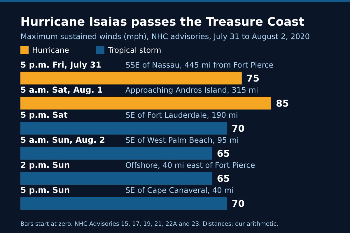
Hurricane Isaias 2020 at a glance
| Advisory time | Where the center was | Distance from Fort Pierce | Maximum winds |
|---|---|---|---|
| 5 a.m. Friday, July 31 | About 15 miles south-southwest of Great Inagua Island | About 630 miles | 80 mph (hurricane) |
| 5 p.m. Friday | About 195 miles south-southeast of Nassau | About 445 miles | 75 mph (hurricane) |
| 5 a.m. Saturday, Aug. 1 | About 80 miles south-southeast of Nassau | About 315 miles | 85 mph (hurricane) |
| 5 p.m. Saturday | About 115 miles southeast of Fort Lauderdale | About 190 miles | 70 mph (tropical storm) |
| 5 a.m. Sunday, Aug. 2 | About 45 miles southeast of West Palm Beach | About 95 miles | 65 mph (tropical storm) |
| 11 a.m. Sunday | About 55 miles southeast of Fort Pierce | About 55 miles | 65 mph (tropical storm) |
| 2 p.m. Sunday | About 45 miles east-southeast of Vero Beach | About 40 miles | 65 mph (tropical storm) |
| 5 p.m. Sunday | About 65 miles southeast of Cape Canaveral | About 40 miles | 70 mph (tropical storm) |
The advisories forecast surge and rain by stretch of coast and reported gusts by place. None of the sources on this page gives measured wind speeds, rain totals, surge heights or damage figures for St. Lucie County, so we have not printed any.
After Florida
Isaias turned north off Georgia, the Weather Prediction Center records, regained hurricane strength on the afternoon of August 3 about 100 miles south of Charleston, and made its fourth and final landfall that night near Ocean Isle Beach, North Carolina. It then raced north-northeast through the mid-Atlantic states and New England with heavy rain, damaging winds and tornadoes, and became an extratropical low on the evening of the 4th as it crossed from Vermont into Canada.
What Isaias shows
A warning is issued on a forecast, and forecasts move. At 11 p.m. Saturday the Hurricane Center still expected hurricane conditions on our coast by Sunday morning and thought Isaias could regain hurricane strength overnight. Six hours later it had not, and the Hurricane Warning came down. The 36 hours before that were the time to get ready.
A center offshore still reaches the coast. At 11 a.m. Sunday the center was about 55 miles out, and tropical-storm-force gusts had been observed from Juno Beach to Port St. Lucie. What a Tropical Storm Warning asks of you is in weather alert types explained, and the surf a passing storm leaves behind is in rip currents on the Treasure Coast.
Warnings come down one stretch of coast at a time. Ours ended at 5 p.m. Sunday, while the Tropical Storm Warning still ran from Sebastian Inlet north to Ocracoke Inlet, North Carolina. Go by the warning for your own stretch of coast before going back out.
Frequently asked questions about Hurricane Isaias
Sources
- Weather Prediction Center, Hurricane Isaias, July 31 to August 4, 2020 (formation and track, the Andros landfall, the closest approach to southeast Florida, the North Carolina landfall, the end of the storm, rainfall maps).
- National Hurricane Center, Hurricane Isaias Advisory 13, 5 a.m. Friday, July 31, 2020; Advisory 15, 5 p.m. Friday.
- National Hurricane Center, Advisory 17, 5 a.m. Saturday, August 1; Advisory 19, 5 p.m. Saturday; Advisory 20, 11 p.m. Saturday.
- National Hurricane Center, Advisory 21, 5 a.m. Sunday, August 2; Advisory 22, 11 a.m. Sunday; Intermediate Advisory 22A, 2 p.m. Sunday; Advisory 23, 5 p.m. Sunday.
Before the next storm
Watch what is coming with our St. Lucie County alerts page and the live radar, or open the command center for everything at once. For other storms that passed offshore, read Hurricane Dorian, 2019 and Hurricane Matthew, 2016; for one that came ashore near Vero Beach, Hurricane Nicole, 2022. The rest is in Treasure Coast hurricane history, and getting ready starts with the hurricane preparedness guide.