Fay struck Cape Romano on Florida’s southwest coast as a moderate tropical storm, the Weather Prediction Center records, and kept getting better organized after landfall. Its center crossed the peninsula north-northeast past Lake Okeechobee and came by the Treasure Coast on the inland side, west and then northwest of Fort Pierce, on the evening of Tuesday, August 19, 2008. It then stalled off the coast between Melbourne and Daytona Beach for about a day and a half, raining on east-central Florida, before it moved back ashore near Flagler Beach.
This page follows those days through the National Hurricane Center’s advisories, with the Weather Prediction Center’s storm summary for the start and the end of the storm, all listed under Sources at the end. Times are Eastern Daylight Time. The distances from Fort Pierce are our own arithmetic from the positions in each advisory, except where we quote the Hurricane Center’s own.
Before Florida
Fay grew out of a tropical wave and an area of low pressure that crossed the Atlantic and organized near the northern Leeward Islands and Puerto Rico, the Weather Prediction Center records. It was named on August 15, moved west across southern Hispaniola and central Cuba, and came out into the Florida Straits.
Monday, August 18: the watch, then the warning
5 a.m. Fay was over central Cuba with maximum sustained winds near 50 mph, about 345 miles from Fort Pierce. A Tropical Storm Warning went up on Florida’s east coast from Jupiter Inlet southward, and a Tropical Storm Watch from north of Jupiter Inlet to Sebastian Inlet, which took in St. Lucie County. The Hurricane Center expected Fay to become a hurricane before it reached the Florida peninsula.
5 p.m. The center was near Key West with winds near 60 mph, about 220 miles from Fort Pierce. This advisory put a Hurricane Warning on the southwest coast from Flamingo to Anna Maria Island and extended the Tropical Storm Warning on the east coast north to Flagler Beach. From here on, St. Lucie County was under a Tropical Storm Warning.
Tuesday, August 19: across the state and past Fort Pierce
5 a.m. Fay was making landfall at Cape Romano, about 55 miles south of Fort Myers and about 135 miles from Fort Pierce, with winds near 60 mph. It had not become a hurricane, and every Hurricane Warning was discontinued.
11 a.m. The center was about 20 miles southwest of Moore Haven, on the west side of Lake Okeechobee, about 80 miles from Fort Pierce. The headline said Fay was in no hurry to cross the peninsula. The advisory forecast 5 to 10 inches of rain over the southern and east-central peninsula, with up to 15 inches in places, and storm tides of 1 to 3 feet above normal along the east coast. The Weather Prediction Center notes that South Florida Water Management District stations over Lake Okeechobee measured higher winds than anywhere before landfall, which led the Hurricane Center to raise Fay’s winds as it crossed.
5 p.m. The center was about 60 miles south-southwest of Melbourne, about 43 miles west of Fort Pierce, with winds near 65 mph, as strong as Fay got in any advisory on this page. A South Florida Water Management District station on the central Kissimmee River had just reported a gust of 60 mph, and the advisory put tropical-storm-force winds as far as 175 miles from the center. The warning south of Jupiter was discontinued; ours stayed up.
7 p.m. and 9 p.m. Both advisories placed the center about 45 miles south-southwest of Melbourne, about 35 miles from Fort Pierce; it had moved little in between. By 9 p.m. the winds had eased to near 60 mph.
11 p.m. After a few hours of erratic motion, the center was about 30 miles south-southwest of Melbourne, about 29 miles northwest of Fort Pierce, as close as any position in these advisories. Radar and surface observations had the winds down to near 50 mph, and the advisory expected Fay to move just offshore on Wednesday and stay near the coast through Thursday.
Wednesday and Thursday: stalled offshore
5 a.m. Wednesday, August 20. The center was very near Melbourne, moving north near 5 mph, with its strongest winds mostly over the water well east of the center.
11 a.m. Wednesday. The Tropical Storm Warning was discontinued south of Fort Pierce, which took Port St. Lucie out of it after 42 hours. The warning now ran from Fort Pierce north to Altamaha Sound, Georgia. The center was about 15 miles north of Cape Canaveral, drifting north near 3 mph, and the advisory passed on an unofficial report of near 16 inches of rain at Satellite Beach.
11 p.m. Wednesday. Fay had been nearly stationary for several hours about 35 miles southeast of Daytona Beach, and the headline said very heavy rain continued along the east coast of central Florida. The forecast now allowed for isolated storm totals of 30 inches in Florida.
11 a.m. Thursday, August 21. Still stationary, about 15 miles east-northeast of Daytona Beach. The advisory said isolated storm totals of 20 to 30 inches had been observed over the east-central coastal areas of Florida. Fay came back ashore near Flagler Beach at about 2:30 that afternoon.
11 p.m. Thursday. The Tropical Storm Warning on the east coast now began at Sebastian Inlet. Fort Pierce had been under it since 5 p.m. Monday, more than three days.
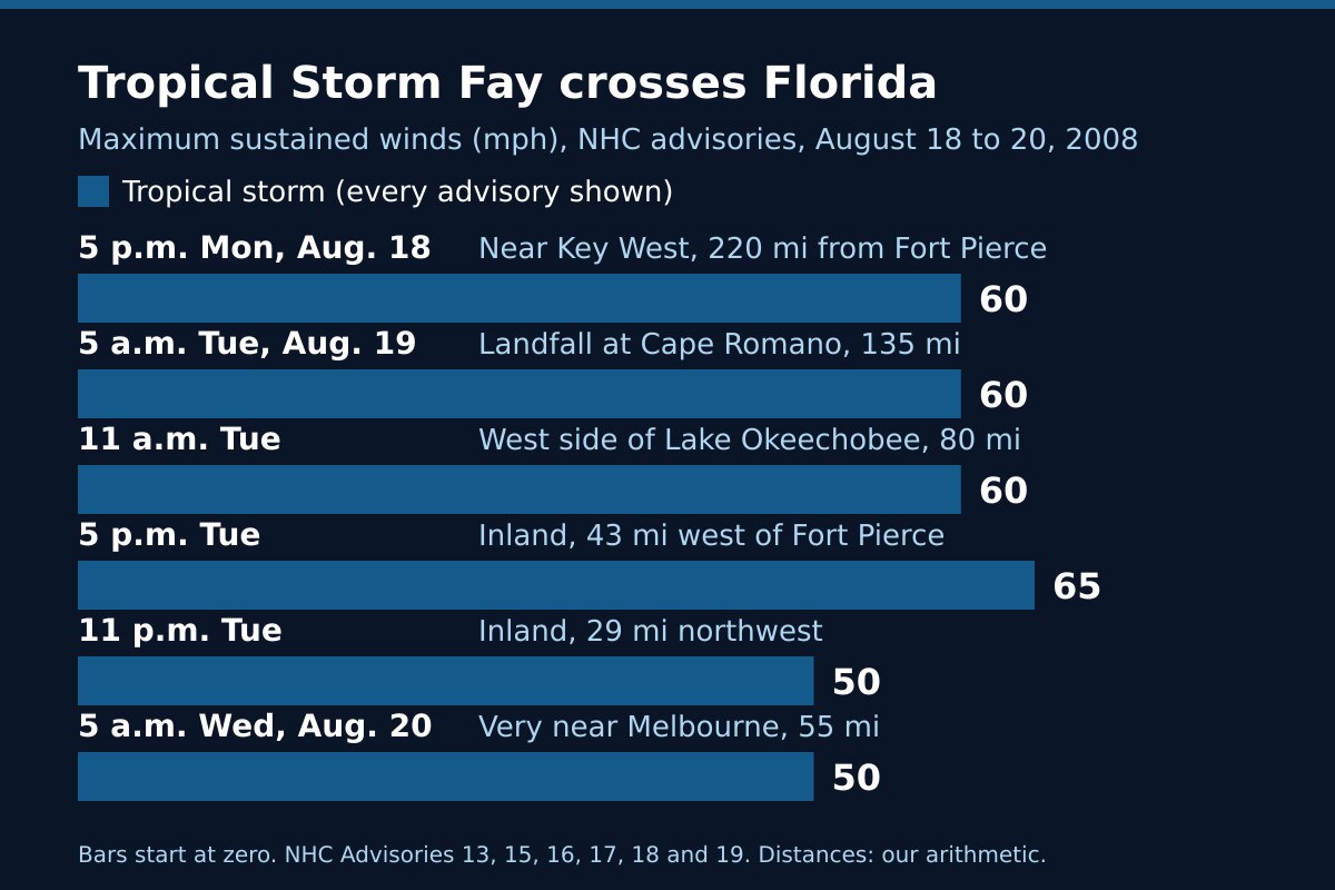
Tropical Storm Fay 2008 at a glance
| Advisory time | Where the center was | Distance from Fort Pierce | Maximum winds |
|---|---|---|---|
| 5 a.m. Monday, Aug. 18 | Over central Cuba | About 345 miles | 50 mph |
| 5 p.m. Monday | Near Key West | About 220 miles | 60 mph |
| 5 a.m. Tuesday, Aug. 19 | Landfall at Cape Romano | About 135 miles | 60 mph |
| 11 a.m. Tuesday | About 20 miles southwest of Moore Haven | About 80 miles | 60 mph |
| 5 p.m. Tuesday | About 60 miles south-southwest of Melbourne | About 43 miles | 65 mph |
| 11 p.m. Tuesday | About 30 miles south-southwest of Melbourne | About 29 miles | 50 mph |
| 5 a.m. Wednesday, Aug. 20 | Very near Melbourne | About 55 miles | 50 mph |
| 11 p.m. Wednesday | About 35 miles southeast of Daytona Beach | About 100 miles | 60 mph |
Every row is a tropical storm. The advisories forecast rain and tides by region and reported gusts and rain totals by place. None of the sources on this page gives measured wind speeds, rain totals, tide heights or damage figures for St. Lucie County, so we have not printed any.
After Florida
Fay crossed the northern peninsula slowly, the Weather Prediction Center records, came out into Apalachee Bay on the 23rd and made landfall again near Carrabelle. It stalled over Mississippi on the 24th and became an extratropical low on the 26th, bringing heavy rain to the southern Appalachians, where over a foot fell in parts of northeast Georgia and western North Carolina. What was left of it was absorbed over southern Ohio on the 28th.
What Fay shows
A tropical storm can be the long one. Fort Pierce was under a Tropical Storm Warning for more than three days, longer than St. Lucie County was under the Hurricane Warning for Hurricane Isaias in 2020. A slow storm keeps its wind and rain over the same towns for as long as it lingers.
A center inland still reaches the coast. Fay passed between 29 and 43 miles west and northwest of Fort Pierce on Tuesday evening, with tropical-storm-force winds reaching out as far as 175 miles. What a Tropical Storm Warning asks of you is in weather alert types explained.
The rain falls where the storm stops. On Tuesday morning the forecast was 4 to 8 inches. Two days later, with Fay parked off the coast, 20 to 30 inches had been observed in places along the east-central coast. Rain like that puts water over roads, and flooded roads in St. Lucie County covers what to do when one is under water.
Frequently asked questions about Tropical Storm Fay
Sources
- Weather Prediction Center, Tropical Storm Fay, August 14 to 28, 2008 (formation and track, the Cape Romano landfall, the Lake Okeechobee winds, the stall off east-central Florida, the later landfalls, the end of the storm, rainfall maps).
- National Hurricane Center, Tropical Storm Fay Advisory 11, 5 a.m. Monday, August 18, 2008; Advisory 13, 5 p.m. Monday.
- National Hurricane Center, Advisory 15, 5 a.m. Tuesday, August 19; Advisory 16, 11 a.m.; Advisory 17, 5 p.m.; Intermediate Advisory 17A, 7 p.m.; Intermediate Advisory 17B, 9 p.m.; Advisory 18, 11 p.m.
- National Hurricane Center, Advisory 19, 5 a.m. Wednesday, August 20; Advisory 20, 11 a.m.; Advisory 21, 5 p.m.; Advisory 22, 11 p.m.
- National Hurricane Center, Advisory 24, 11 a.m. Thursday, August 21; Advisory 25, 5 p.m.; Advisory 26, 11 p.m.
Before the next storm
Watch what is coming with our St. Lucie County alerts page and the live radar, or open the command center for everything at once. For another storm that crossed the state from the Gulf side, read Hurricane Wilma, 2005; for storms that came ashore on our own coast, Hurricanes Frances and Jeanne, 2004. The rest is in Treasure Coast hurricane history, and getting ready starts with the hurricane preparedness guide.