Before a run out of Fort Pierce Inlet or St. Lucie Inlet, the Port St. Lucie marine forecast to read is the National Weather Service’s, written by its forecast office in Melbourne. It is plain text, it is written in its own shorthand, and it answers the questions a captain asks: how hard the wind will blow, how big the seas will be, and what the inside water will feel like.
This page explains which part of that forecast covers our coast, how to read each line of it, and what one real forecast said. Every definition here comes from the forecast itself; the sources are listed at the end.
The two zones that cover the Treasure Coast
The Melbourne office's Coastal Waters Forecast covers the “Atlantic coastal waters from Flagler Beach to Jupiter Inlet out 60 nm,” split into six zones. Two of them are ours:
- AMZ555, Sebastian Inlet to Jupiter Inlet 0-20 nm. The near water, from the beach out to 20 nautical miles. Its forecast also describes the intracoastal waters.
- AMZ575, Sebastian Inlet to Jupiter Inlet 20-60 nm. The same stretch of coast, from 20 out to 60 nautical miles.
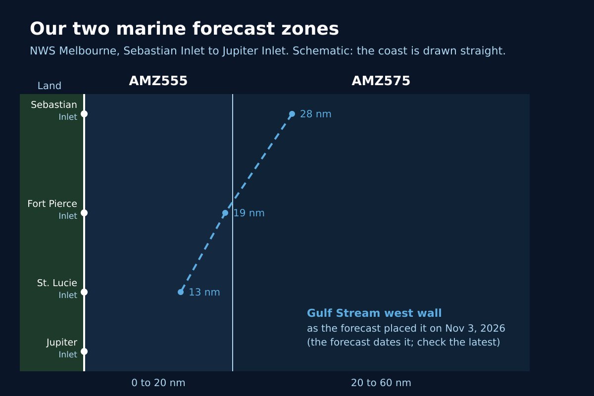
Each zone carries a code that starts with AMZ. The code is how the forecast labels each section, so it is the quickest thing to look for when you open the full text.
How a zone forecast reads
A zone forecast runs period by period: TONIGHT, then each day and night for the next several days. Each period gives the wind, the seas, often a wave detail, and for the near zone a word on the intracoastal waters. Here is what each part means.
- Headline. If an advisory or warning is in effect, it sits above the forecast in capital letters, with its end time. On November 3, 2026 that line read “SMALL CRAFT ADVISORY IN EFFECT UNTIL 7 PM EST THIS EVENING.”
- Winds. The direction the wind blows from and its speed in knots, such as “East winds 15 to 20 knots,” sometimes with a change through the period, such as “diminishing to 5 to 10 knots in the afternoon.”
- Seas. A range in feet, often with an “occasionally” figure. The forecast defines both: “Seas are provided as a range of the average height of the highest one third of the waves, along with the occasional height of the average highest ten percent of the waves.” So in “seas 5 to 7 feet, occasionally to 9 feet,” expect some waves near 9 feet.
- Wave detail. The seas broken into wave trains: the direction each comes from, its height, and its period in seconds. “Northeast 5 feet at 8 seconds and southeast 1 foot at 5 seconds” means two sets of waves arriving at once. Our guide to the Fort Pierce buoy explains wave period and shows what the sea actually did.
- Intracoastal waters. In the near zone, a one-word picture of the inside water. The November 3 forecast used five: smooth, mostly smooth, a light chop, a moderate chop, and choppy.
- The closing line. Each of our two zones ends with a reminder such as “Winds and waves higher in and near thunderstorms.” The numbers above it do not cover a storm cell.
The synopsis and the Gulf Stream
Before the zones comes a synopsis for the whole area, zone AMZ500. It explains the weather pattern in a few sentences: where the high or low pressure sits, which way the wind is pushing the sea, and what will change over the coming days. It is the part to read if you want to know why the numbers are what they are.
The synopsis also carries a Gulf Stream section: the seas and winds expected in the stream, and the approximate location of its west wall, “based on the Real Time Ocean Forecast System,” as a distance east of each inlet. On November 3, 2026 it read 28 nautical miles east of Sebastian Inlet, 19 east of Fort Pierce Inlet and 13 east of St. Lucie Inlet. The forecast dates that reading, so take it from the latest forecast rather than from memory.
Reading a real Port St. Lucie marine forecast: November 3, 2026
The forecast issued at 1:31 pm on Tuesday, November 3, 2026 opened its synopsis with “Moderate to fresh onshore flow” on the southern side of a strong high to the north of Florida, causing rough seas and hazardous boating conditions. It expected the winds to ease and the seas to subside as the high weakened later in the week, and a long-period swell from low pressure northeast of the Bahamas from Friday night into the weekend, which “may cause hazardous conditions, especially near inlets.”
For zone AMZ555, the near water off our coast, it read like this:
- Tuesday night: east winds 15 to 20 knots, seas 5 to 7 feet, occasionally to 9 feet, wave detail east 6 feet at 7 seconds, choppy on the intracoastal waters, under a Small Craft Advisory in effect until 7 pm that evening.
- Wednesday: east winds 10 to 15 knots, seas 4 to 5 feet, occasionally to 6 feet, a moderate chop inside.
- Thursday: northeast winds 5 to 10 knots, seas 3 to 4 feet, a light chop inside.
- Friday: northeast winds around 5 knots, seas 3 to 4 feet, smooth inside.
Farther out, zone AMZ575 called for east winds around 20 knots Tuesday night and the same 5 to 7 foot seas, occasionally to 9 feet. Read top to bottom, the forecast told a simple story: a rough Tuesday, a day of settling, and a calm stretch to end the week, with a swell to watch at the inlets over the weekend.
Where to find the forecast
The Melbourne office’s marine page links the full Coastal Waters Forecast, along with the Surf Zone Forecast for the beaches, Special Marine Warnings and Marine Weather Statements. For the beach rather than the boat, the surf zone forecast and our page on rip currents are the better read.
Frequently asked questions about the marine forecast
Sources
- National Weather Service Melbourne, Coastal Waters Forecast for East Central Florida (text product; the issue of 1:31 pm EST, November 3, 2026 is quoted here).
- National Weather Service Melbourne, East Central Florida Marine Weather.
Before you head out
Check for storms on the live radar, see whether a marine or beach alert is up on our St. Lucie County alerts page, or open the command center for everything at once. Once you are out, our guide to lightning safety covers what to do when a storm builds.