Hurricane Irma is the storm whose center stayed on the far side of Florida from us. It crossed the Lower Keys on Sunday, September 10, 2017, and moved north through the western half of the peninsula that night. At 11 p.m. its center was about 95 miles west of Fort Pierce. By Saturday morning the Treasure Coast was under a Hurricane Warning, and the warning stayed up until early Monday.
This page follows those days through the National Hurricane Center’s advisories and a forecast discussion, with the Weather Prediction Center’s storm summary for the start and the end of the storm, all listed under Sources at the end. Times are Eastern Daylight Time, as the advisories gave them. The distances from Fort Pierce are our own arithmetic from the positions in each advisory.
Before Florida
Irma began as a tropical wave that moved off western Africa on August 27, the Weather Prediction Center records. It strengthened fast, becoming a hurricane early on August 31 and a major hurricane that evening. It struck Barbuda and St. Martin, passed north of Puerto Rico and the Dominican Republic, came ashore on Little Inagua in the Bahamas, and made landfall on the north coast of Cuba at Cayo Romano on the night of September 8.
Saturday, September 9: the warning
5 a.m. The eye was moving over Cuba’s Camaguey Archipelago, about 245 miles south-southeast of Miami, with maximum sustained winds near 155 mph, Category 4. With this advisory the Hurricane Warning on Florida’s east coast was extended north to the Flagler and Volusia county line, so it ran from there south and around the whole peninsula to Chassahowitzka on the Gulf coast. A Storm Surge Warning covered the coast from the Volusia and Brevard county line southward.
The forecast track took the center near the Florida Keys on Sunday morning and near the southwest coast on Sunday afternoon. Hurricane-force winds reached out up to 70 miles from the center and tropical-storm-force winds up to 195 miles. For the coast from Boca Raton to the Flagler and Volusia line, the advisory forecast 2 to 4 feet of storm surge above ground if the peak came at high tide, and it forecast 8 to 15 inches of rain for the Florida peninsula, with isolated amounts of 20 inches.
Sunday, September 10: the Keys and the west coast
11 a.m. The center was about 80 miles south-southeast of Naples, with winds near 130 mph, still Category 4, and the advisory said the eye should move over the Lower Florida Keys shortly. A gust of 120 mph had been reported at the National Key Deer Refuge on Big Pine Key, and Miami International Airport had reported a sustained wind of 62 mph with a gust of 94 mph. Hurricane-force winds now reached up to 80 miles from the center and tropical-storm-force winds up to 220 miles.
The forecast discussion issued with that advisory put the reason for the wide warning in one line of its key messages: “Irma will bring life-threatening wind impacts to much of Florida regardless of the exact track of the center.”
11 p.m. NOAA Doppler radar placed the center about 40 miles east-northeast of Sarasota and about 50 miles southeast of Tampa, moving north near 14 mph. That put it about 95 miles west of Fort Pierce and of Vero Beach. Its winds had dropped to near 100 mph, and the advisory called its wind field very large: hurricane-force winds up to 80 miles from the center, and tropical-storm-force winds up to 415 miles.
South of Jupiter Inlet the Hurricane Warning was changed to a Tropical Storm Warning, while from Jupiter Inlet north to Fernandina Beach it stayed in force. For that stretch the advisory now forecast 3 to 5 feet of storm surge above ground at high tide, and 8 to 12 inches of rain for the eastern peninsula, with isolated amounts of 16 inches.
Monday, September 11: the warning comes down
5 a.m. The center was about 35 miles east-southeast of Cedar Key, moving north-northwest near 18 mph, with winds near 75 mph. On the east coast from Sebastian Inlet south to Jupiter Inlet, and on Lake Okeechobee, the Hurricane Warning was changed to a Tropical Storm Warning. Tropical-storm-force winds still reached up to 415 miles from the center, and the Mayport Naval Station near Jacksonville had just reported a sustained wind of 68 mph with a gust of 87 mph.
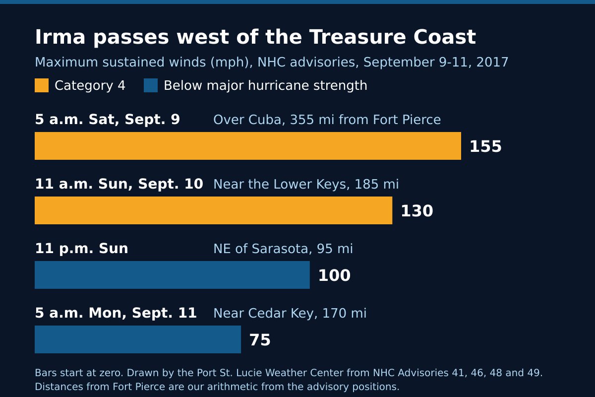
The three days at a glance
| Advisory time | Where the center was | Distance from Fort Pierce | Maximum winds |
|---|---|---|---|
| 5 a.m. Saturday, Sept. 9 | Over Cuba’s Camaguey Archipelago | About 355 miles | 155 mph (Category 4) |
| 11 a.m. Sunday, Sept. 10 | About 80 miles south-southeast of Naples, near the Lower Keys | About 185 miles | 130 mph (Category 4) |
| 11 p.m. Sunday | About 40 miles east-northeast of Sarasota | About 95 miles | 100 mph |
| 5 a.m. Monday, Sept. 11 | About 35 miles east-southeast of Cedar Key | About 170 miles | 75 mph |
The surge and rain figures above were forecasts. The sources on this page do not give measured winds, water levels, rain totals or damage figures for St. Lucie County, so we have not printed any.
After Florida
After the Keys, Irma came ashore again in southwest Florida later on September 10, then weakened as it crossed the Florida landmass and met an upper-level trough, the Weather Prediction Center records. It moved on to the northwest, into southeast Missouri and then southern Illinois, and dissipated on the afternoon of September 13.
What Irma shows
The warning follows the size of the storm. On Sunday night Irma’s tropical-storm-force winds reached out up to 415 miles, and its hurricane-force winds up to 80 miles. A center 95 miles away is close to a storm that wide, which is why the Hurricane Warning on this coast stayed up until Monday morning.
Read the forecast for your own coast. With the center on the Gulf side, the advisories still carried a storm surge forecast for the Atlantic coast from Jupiter Inlet north, and 8 to 12 inches of rain for the eastern peninsula. Those were the lines that applied here.
A cone on the other side of the state is still a reason to get ready. On Saturday morning the whole peninsula was under a Hurricane Warning, the Treasure Coast included, and it stayed that way on this coast until the center was past Tampa.
Frequently asked questions about Hurricane Irma
Sources
- Weather Prediction Center, Hurricane Irma, September 2017 (formation, the Caribbean and Cuba, the Cudjoe Key and southwest Florida landfalls, weakening, the end of the storm).
- National Hurricane Center, Hurricane Irma advisory archive.
- National Hurricane Center, Hurricane Irma Advisory 41, 5 a.m. Saturday, September 9, 2017; Advisory 46 and Discussion 46, 11 a.m. Sunday, September 10; Advisory 48, 11 p.m. Sunday; Advisory 49, 5 a.m. Monday, September 11.
Before the next storm
Watch what is coming with our St. Lucie County alerts page and the live radar, or open the command center for everything at once. What each warning means is in weather alert types explained. For storms that passed offshore, read Hurricane Matthew, 2016 and Hurricane Dorian, 2019; for one that crossed the state from the Gulf side, Hurricane Ian, 2022; for storms that came ashore, Hurricanes Frances and Jeanne, 2004 and Hurricane Nicole, 2022. The rest is in Treasure Coast hurricane history, and getting ready starts with the hurricane preparedness guide.