On Thursday afternoon, November 5, 2026, the National Weather Service office in Melbourne put this line in the key messages of its forecast discussion:
“A dry cold front will push through Saturday and bring somewhat cooler temperatures.”
This page explains what that means for St. Lucie County: what a front is, what changes when one goes by, and why some bring rain and others bring only a change in the wind. The forecast for this weekend serves as the worked example. The sources are linked at the bottom.
What a cold front is
NOAA’s Weather Prediction Center, which publishes the national surface weather maps, gives the Weather Service glossary definition:
“Cold Front - a zone separating two air masses, of which the cooler, denser mass is advancing and replacing the warmer.”
On a weather map a cold front is a blue line with blue triangles along it. The triangles sit on the side the front is moving toward, so they face the places it has yet to reach. A front that is moving very slowly or not at all is called a stationary front.
The front itself is the boundary. What you notice at home is the change from the air ahead of it to the air behind it.
How the November 7 front was forecast to pass
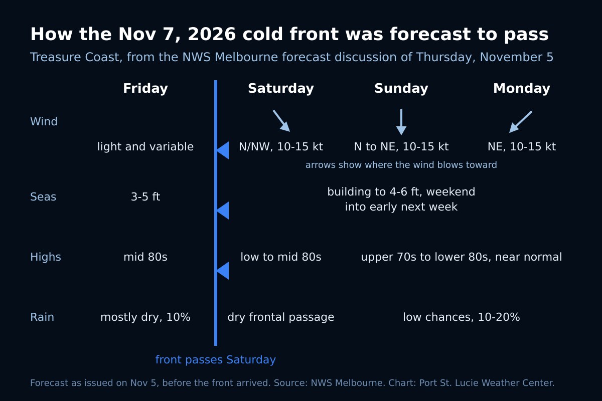
Friday. The discussion placed a weak front across the southeastern United States, pushing slowly southeastward. Ahead of it, highs were expected in the mid 80s, warmer than normal, with overnight lows in the mid to upper 60s. The point forecasts for Fort Pierce and Vero Beach carried a 10 percent chance of rain. Thursday night into Friday morning also brought a 40 to 50 percent chance of patchy fog, the kind our dense fog advisory page covers.
Saturday. The front was forecast to push south through central Florida. Two sentences in the discussion carry most of what this page is about:
“Limited moisture with this boundary means it will likely be a dry frontal passage. A wind shift out of the N/NW will announce its passage.”
Saturday itself was still expected to be warm, in the low to mid 80s.
Sunday and Monday. As high pressure builds in behind the front, the discussion expected the wind to keep turning: north to northeast on Sunday, northeast on Monday. Highs were forecast near normal, in the upper 70s to lower 80s, from Sunday through Tuesday, with lows in the 60s across most of the area.
What to watch when a front comes through
- The wind. For this weekend’s front, the forecasters named a shift to the north or northwest as the sign it had arrived, with the wind then coming around to the northeast as high pressure built in behind it.
- The moisture. The forecasters tied this front’s dry passage to its limited moisture, and left rain out of the weekend forecast.
- The temperature. In this forecast Saturday stayed in the low to mid 80s, and the cooler air showed in the highs from Sunday, a few degrees lower. If a stronger one ever brings a forecast near freezing, our freeze warning and frost advisory page explains the alerts.
Fronts and the water
For the coastal waters, the discussion forecast light and variable winds on Friday ahead of the front, a switch to north or northwest at 10 to 15 knots as it crossed on Saturday, then northeast at 10 to 15 knots from Sunday into early next week. Seas of 3 to 5 feet through late week were forecast to build to 4 to 6 feet over the weekend, and the discussion warned that the mix of wind wave and swell would make for poor boating conditions, especially offshore.
Before heading out after a front, read the forecast for your zone on our marine forecast zones page and check what the Fort Pierce buoy is reporting. Our sea breeze guide covers the everyday wind cycle along the coast.
A dry spell after a wet week
This front followed the heavy rain of November 1 to 3. The same discussion still opened with a warning to avoid flooded roads in the areas hit hardest, and it called for only low rain chances, 10 to 20 percent, for several days. For anyone still dealing with standing water, our flooded roads page has the Weather Service and CDC guidance.
The forecast for the middle of next week was less settled. The discussion noted that two of the main computer models disagreed on when the next disturbance would cross Florida, one bringing more rain on Wednesday and the other holding it off until Wednesday night or Thursday. Forecasts that far out change, which is why the live pages below are the ones to trust on the day.
Frequently asked questions about cold fronts on the Treasure Coast
Sources
- National Weather Service Melbourne, Area Forecast Discussion, key messages, discussion and marine sections issued 1:27 pm EST, Thursday, November 5, 2026; point forecasts from the 6:21 pm EST issue (the link always shows the latest issue).
- NOAA Weather Prediction Center, Product Legends: surface fronts and boundaries, definitions derived from the National Weather Service Glossary.
When the next front is on the way
Watch it arrive on the live radar, check the St. Lucie County alerts page for anything the Weather Service issues, or open the command center for wind, temperature and alerts in one place.